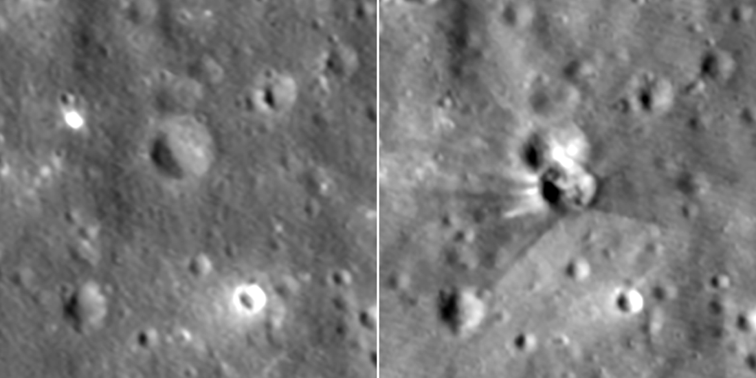
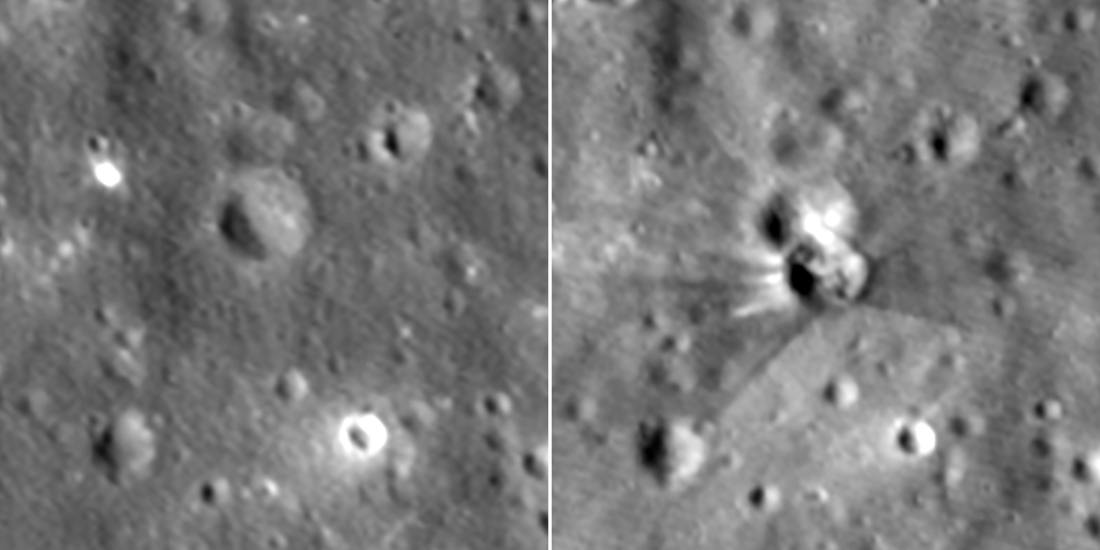
A spent Falcon 9 upper stage hit the Moon on 5 August 2026. NASA’s Lunar Reconnaissance Orbiter photographed the scar six days later. The crater is 18 meters across and less than 3 meters deep. JPL’s Center for Near Earth Object Studies had pointed South Korea’s Danuri orbiter to the right neighborhood first: the prediction was off by about 0.6 miles.
That is a real measurement. It is not a planetary-defense intercept, and it is not a new class of lunar science until someone repeats it on a natural object.
What happened
NASA’s Science editorial team posted the agency write-up on 18 August 2026. Mark Robinson’s LROC featured-image note, also 18 August, supplies the metric crater size and the imaging geometry. Both pages were fetched for this article; the numbers below appear on one or both.
The booster had launched in January 2025 with Firefly’s Blue Ghost 1. After that mission it remained in a trajectory that, months later, intersected the Moon. Independent astronomers first flagged the path from public tracking data. NASA’s Center for Near Earth Object Studies (CNEOS) at JPL, which exists to track natural objects that could hit Earth, used the event to exercise the same impact-prediction tools.
CNEOS produced two 2.1-mile by 0.4-mile error ellipses. Both used the same booster-trajectory calculation. Only the blue ellipse folded in lunar terrain. The red and blue dots on NASA’s figure are predicted impact points; the cyan dot is the crater NASA later measured.
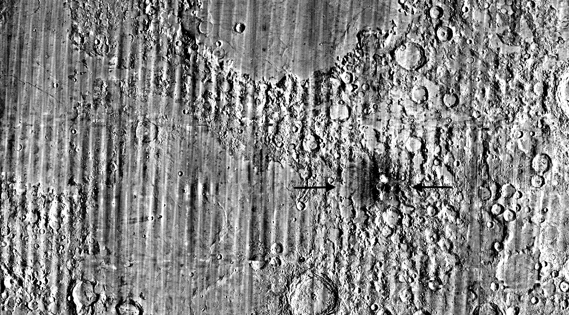
CNEOS sent the location to the Korea Aerospace Research Institute. A few hours after impact, Korea Pathfinder Lunar Orbiter (Danuri) pointed its LUTI camera at the predicted site, compared the frame with a pre-impact image, and found the crater. KARI then passed coordinates to the LRO team. NASA says that first prediction was accurate to about 0.6 miles.
LRO still had to wait. The orbiter flies pole to pole about every two hours. NASA’s write-up puts the altitude at about 60 miles, speed 1 mile per second; LROC’s note puts the 11 August pass at 90 kilometers. The Moon had to rotate the impact site under the ground track, which took six days. A shutter 10 seconds early or late would have put the crater 10 miles off-center.
Between 11 and 12 August, LRO’s Narrow-Angle Camera — NASA says it can resolve features as small as 3 feet — took a sequence of views. On the 11th, LROC acquired five images, one every 117 minutes. Slews were 23° west, 11° west, 4° east, 17° east and 28° east. Thirteen and a half hours later the spacecraft slewed 68° east for an oblique view. Incidence angles in the sequence ran 67° to 71°; phase angle ran 105° to 37°.
Comparing the new frames with a pre-impact NAC image, the LROC team fixed the crater center at 19.4759°N, 266.7138°E, 511 meters elevation.
NASA’s public note reports the rim as 60 feet wide and the floor as less than 10 feet deep from the shadow. LROC’s camera-team note, using the same images, reports 18 meters diameter and less than 3 meters deep. Those are the same crater, in two unit systems. This article uses LROC’s 18 m / <3 m as the measurement and NASA’s 60-foot / <10-foot line as the agency’s rounded public figure.
Chart-ready numbers
| Quantity | Value | Source |
|---|---|---|
| Impact | 5 Aug 2026, 6:35 UTC | LROC, 18 Aug 2026 |
| First LRO NAC sequence | 11–12 Aug 2026 | NASA Science, 18 Aug |
| Crater diameter | 18 m (NASA public: ~60 ft) | LROC / NASA Science |
| Crater depth (shadow) | <3 m (NASA public: <10 ft) | LROC / NASA Science |
| Center | 19.4759°N, 266.7138°E, 511 m elevation | both |
| CNEOS error ellipses | 2.1 × 0.4 miles | NASA Science |
| CNEOS residual vs crater | ~0.6 miles | NASA Science |
| Impact angle | ~31° from horizontal | LROC |
| Weathered ejecta depth | ~50 cm (NASA: 1.5 ft) | LROC / NASA Science |
| NAC resolution (NASA) | features as small as 3 ft | NASA Science |
| LRO altitude at imaging | ~90 km (LROC); ~60 miles (NASA) | both |
| Orbit period used for cadence | 117 minutes between NAC frames | LROC |
The images show mixed dark and bright rays. NASA and LROC agree on the geology even when they round the units differently. Dark streaks are mature surface regolith, darkened by solar wind, galactic cosmic rays and micrometeorites, excavated from roughly the top 50 centimeters (NASA: 1.5 feet). Bright rays near the rim are fresher material from below that layer. A V-shaped ejecta pattern on the south side matches a low-angle impact; LROC puts the booster at about 31° from horizontal. The “forbidden zone” of missing ejecta on the uprange side is the same geometry natural meteoroids leave.
Why it matters
CNEOS is a planetary-defense shop. Its day job is natural near-Earth objects. A rocket body is not an asteroid, but the geometry problem is the same: take a poorly observed trajectory, fold in gravity and terrain, and put a camera on the predicted ellipse before the next orbit is gone. Danuri was on station. LUTI got there first. LRO then spent fuel and slew margin to turn a 0.6-mile cue into an 18-meter crater with a published coordinate.
That is catalog hygiene. NASA already maintains a list of spacecraft-related lunar coordinates; LROC’s related-image links include the Apollo 14 and 16 S-IVB craters and a 2016 update of spacecraft impact sites. Adding a 2026 Falcon 9 crater keeps the map honest so future science teams do not treat a human-made pit as a fresh meteoroid.
The same week, NASA is stacking Falcon Heavy for the Roman Space Telescope — another SpaceX stage, this one still on the ground at Kennedy.
It is also a lighting lesson. With solar incidence almost constant, changing only the camera’s phase angle split roughness from composition: 105° phase made the darkened, roughened halo obvious; 37° phase made the immature bright ejecta obvious. Future impact searches can copy that sequence instead of waiting for a lucky Sun angle.
The 0.6-mile residual is the number that will be quoted. Keep the denominator. The ellipses were 2.1 miles long. Being inside that box, then tightening to 0.6 miles with Danuri, then to a crater center with LRO, is how a tracking pipeline is supposed to close. It is not a demonstration that the same software could deflect a hazardous asteroid.
Limits
One booster. One crater. One trajectory that was public enough for amateur astronomers to notice. The stage was not aimed; it was leftover hardware from a 2025 commercial lunar launch. NASA’s write-up is explicit that CNEOS used the opportunity to “test and validate tools and techniques for predicting impacts.” Validation on a known rocket body is not the same as discovery of a dark natural impactor with days of warning.
The two altitude figures — 60 miles versus 90 km — are both on official pages. They are close (90 km is about 56 miles). This article does not pick a winner; it reports both. Depth is a shadow constraint, not a stereo DEM. Diameter is a rim measurement on enlarged NAC frames, not a laser altimeter profile.
What to watch next
Three follow-ups, all smaller than a press headline. First: does CNEOS publish a residual table for this event, or only the 0.6-mile line? A signed miss distance, in meters, would be the actual score. Second: will LOLA or another altimeter fly over 19.4759°N, 266.7138°E and replace the shadow depth with a topographic one? Third: how many other spent stages are still in cis-lunar space with similarly reconstructable trajectories? A second predicted crater, found before imaging, would show the pipeline is a method and not a one-off.
Until then the sourced claim is narrow: a Falcon 9 upper stage made an 18-meter crater on 5 August 2026; Danuri saw it hours later from a CNEOS cue accurate to about 0.6 miles; LRO published the center on 18 August.